Improving all weather forecast models by measuring the critical, missing piece: Polar Winds
What happens at the poles, doesn't stay at the poles: current weather forecasting models cannot keep up with the pace of climate change and extreme events. What’s worse is there is a missing piece of the forecast puzzle that limits the accuracy and reliability of forecast models. Our NanoSats will provide the data currently missing from weather forecast models
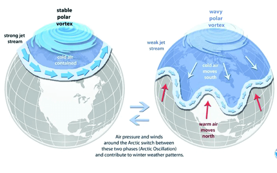
The Polar Winds interact with the jet streams and help drive the majority of weather patterns across the globe. But existing satellites only provide a 2D solution to a 4D problem, measuring winds in just the horizontal axes while vertical winds are sparsely, and poorly, measured by weather balloons and stations. We will leverage our 4D (XYZ + Time) measuring technique to collect wind measurements across all altitudes with greater frequency and higher resolution. This gives forecasters a more accurate starting point to derive their forecasts from.
More Frequent & Complete Measurements of the Polar Vortices will Improve Weather Forecast Models.
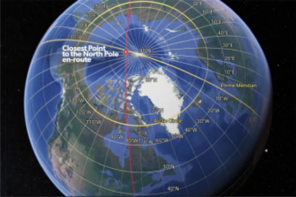
The Polar Vortex drives most weather patterns across the globe. Currently, polar winds are not frequently or comprehensively measured. Weather balloons only cover small regions, GEO Satellites do not observe high latitudes and the few polar orbiting sats can not measure in the vertical axis, only horizontal. A deeper understanding of wind activity at the poles will provide critical data that will help forecasters develop earlier and more reliable prediction models.
Turbines & weather stations only measure surface to ~100m
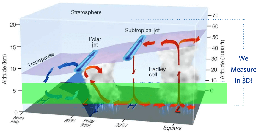
Wind Measurements in the Vertical and Horizontal Axes Provide 3D Jet stream Mapping.
Commercial and Military Aviation rely on weather data from satellites and weather balloons. A critical gap in wind velocity at different altitudes exists as balloons are regional, never at the poles, and only measure every 6 hours. GEO and LEO satellites only measure winds in 2 directions, We deliver accurate and more frequent wind velocity measurements from top to bottom, across all altitudes on a global scale.
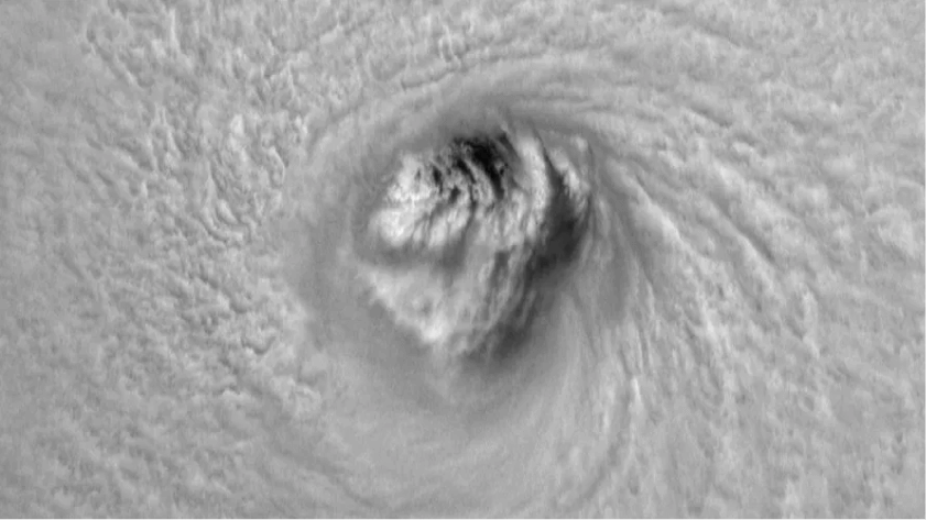
3D, space-based measurements of hurricanes, the Polar Vortex and jet streams that will provide earlier, more accurate forecasts.
Weather impacts everything and extreme climate events such as hurricanes and shifts in the Polar Vortex costs the US over $145 billion dollars in 2021 alone and over $200 billion globally that same year [1]. Now more than ever, governments and industries need earlier, more reliable, and more accurate forecasts to weatherize against disasters and reduce loses from even routine weather events.
Unfortunately, major gaps in global weather data collection prevents this. Current weather and hurricane forecast models lack critical wind measurements from the polar regions and from inside hurricanes to make earlier, more accurate predictions possible. Every year, thousands of lives and hundreds of billions of dollars are lost.
The Climate Crisis is here and only getting worse. It has never been more important for businesses and government infrastructure to weatherize against extreme weather events.
- Texas 2020 freeze from Polar Vortex event caused over $130B in damage
- Hurricane Ida caused over $24 Billion in damage to New York City after being supercharged by jet streams
- Jet streams are changing, harder to navigate do to warming temperatures
- Weather accounts for $600 Million per year in lost revenue in the US
Our Hurricane Hunter Satellites data will introduce a suite of weather prediction software products & apps that provide multiple industries with a competitive advantage through more accurate, reliable weather forecasts
Wait, Isn’t Weather Free? Yes and No...
Custom weather solutions leverage existing satellite and measuring assets to solve specific problems.
A. We rely on billions of dollars worth of government weather assets
B. All private weather companies, from IBM to Accuweather to DTN, also rely on government weather and add value through algorithms, processing, etc.
Hurricane Hunter Satellites
+
$$ Billions worth of Weather & Imagery free from the Government
=
Significant and Unique Upgrade to Weather Forecasts and Products

The Real Cloud Wars: The $6 Billion Battle Over The Future Of Weather Forecasting.

Weather is Turning into Big Business. And That Could be Trouble for the Public.
Rising Global Temperatures are Changing the Jet Stream.
“As the wind shear gets stronger, because of climate change, we expect a lot more turbulence”
- Paul Williams, Professor of Atmospheric Science, University of Reading.*
*Lee SH, Williams PD, Frame THA. Increased shear in the North Atlantic upper-level jet stream over the past four decades. Nature. 2019 Aug;572(7771):639-642.
The aviation industry needs vertical wind measurement in advance to account for dangerous wind shears.
Planes Flying in Close Proximity in the JetStream Need Our Wind Data
Over 1,500 flights per day use the jetstream. Planes are closely bunched in all 3 dimensions:
- 60 miles separate each plane in a row
- 40 miles apart horizontally
- As little as 1,000 ft apart in the vertical
Existing LEO and GEO sats only map wind in 2D and only offer altitude resolution on the kilometer scale; much too large to solve the existing problem. Our 3D wind measurements will provide an altitude resolution +/- 100 Meters.
Key Advantages
Using stereo, we measure cloud altitudes and motion (winds) in precise Earth-centered coordinates with spatial scales to an accuracy of +/- 100 meters and ~2 m/s (~4 mph)
Dozens of observation sessions can be made of targeted areas over most of the globe and repeated at least 3 or 4 times each day. Weather balloons are sent up only twice per day and cover limited region.
LEO imaging constellations consisting of single satellites are unable to produce sufficiently accurate wind measurements
Microwave-based LEO instruments can only approximate horizontal wind components at spatial scales of several km over bodies of water
GEO images can only be used to approximate the horizontal components of wind speed with spatial resolution of several km