NanoSatellite constellation delivers earlier, 2X more accurate hurricane forecasts
Hurricanes cost thousands of lives and $80 billion to $120 billion per year in damages. Warming temperatures across the globe are making hurricanes both more frequent and more intense. It is increasingly vital to predict hurricanes earlier and more accurately. At present, the USA is the only country with a fleet of Hurricane Hunter Aircraft. Our NanoSats will provide similar observation capabilities to twenty vulnerable countries at a fraction of the cost of maintaining a fleet of aircraft.
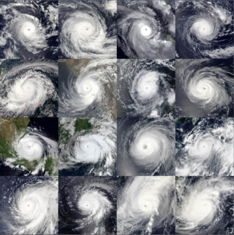
2021 Hurricane Damage
Total Systems – 127
Named Systems – 91
Total Fatalities – 1.332 total
Total Damage – $79.059 billion
Pictured are the 16 tropical cyclones from 2021 that reached at least Category 3 on the saffir-Simpson scale from Faraji in Februarty to Rain in December.
Proven, NASA award winning technology
For over five years, NASA’s Tropical Cyclone Experiment was performed in support of the CyMISS (Tropical Cyclone intensity Measurements from the International Space Station) project funded by CASIS (Center for the Advancement of Science in Space) which manages the ISS US National Laboratory for NASA. The goal of CyMISS was to acquire image sequences from the ISS of intense tropical cyclones (TC’s), such as hurricanes and typhoons, to support the development of an improved remote sensing method to more accurately determine the strength of these destructive storms. In 2017, our advanced hurricane imaging technique earned the Innovation in Earth Science and Remote Sensing Award.
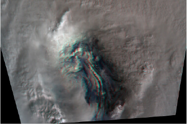
April 22, 2019
CyMISS Image of the
Month: 3D View of
Super Typhoon
Soudelor from the ISS
*Put on your 3D glasses!
NASA astronaut Jack Fischer of ISS Expedition 52 shown taking photographs of Typhoon Noru inside the ISS Cupola during a CyMISS photography session on August 1, 2017. The fixed-mounted Nikon camera pointed out the window to his le was being used to take the photographs in support of CyMISS. (JSC-NASA)
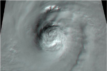
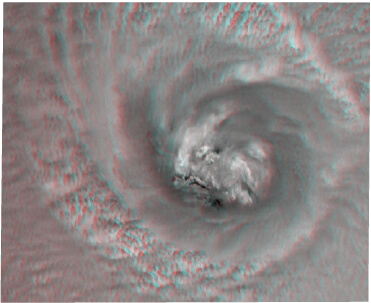
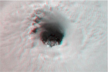
Sept 5, 2017
Closeup View of
the Eye of
Hurricane Irma
from the ISS
*Put on your 3D glasses!
2017 Innovation in Earth Science and Remote Sensing Award for “CyMISS – Cyclone I

Winner
Innovation in Earth Science and Remote Sensing Award
Problems & Challenges with Current Hurricane Observations
- DOPPLER RADAR
- Limited Range (~250 miles).
- Stations are expensive to build, operate, and staff with experts.
- Interferences create uncertainty.
- Lack global coverage.
- GEO SATELLITES
- At 35,000 km from Earth they rely on empirical techniques to estimate hurricane strength.
- Empirical is far less accurate than our physics-based approach.
- HURRICANE HUNTER AIRCRAFT
- Very limited area of coverage ~10% of where hurricanes/TC’s occur.
- Expensive to operate & maintain fleet.
- Limited number of planes/limited observation time.
- Must be in range of airport.
- Mechanical issues sometimes ground flights.
- Can not observe all storms equally when multiple hurricanes occur.
- EXISTING LEO SATELLITES
- Can not produce stereoscopic images needed for 3D model.
- Do not accurately measure cloud heights.
The Hurricane Hunter Satellite Constellation will deliver frequent, near real-time, global coverage of tropical cyclones at a fraction of the cost while delivering up to 4X the accuracy!
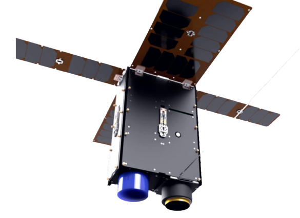
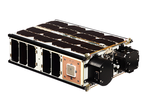
6U NanoSat
7 kg 100 x 226 x 366 mm
4 Pairs of 6U NanoSats deployed in Low Earth Orbit (LEO) with 5-10 year mission life. In addition to advanced measurements, the satellites will collect 3D winds including the polar regions that are of high value to the military, commercial aviation and shipping industry.
Our satellite imagery and algorithms will:
- Enable advanced preparation to save Lives and Property
- Provide forecasters with more accurate data to better predict intensity, path, and landfall of hurricanes, typhoons, and tropical cyclones.
- Build a lucrative enterprise offering high strategic value to the
financial, insurance, government, and aviation markets.
4 Major Components Comprise the Hurricane Hunter Satellite System
1
Proprietary 3D Measurement Platform, Microsatellites, Space Camera & Sensors
Stereoscopic visible/infrared cloud imaging system with unique photogrammetric accuracy referenced to earth centered coordinates
2
Advanced Proprietary Algorithms
Measure cloud top altitudes, incorporate GEO satellite measurements of cloud top temperatures and ocean surface temperatures to derive high accuracy Tropical Cyclone intensity measurements.
3
World-Leading Team for TC Intensities & Tracks
Expertise in the development of proprietary NWP codes that will utilize NanoSat intensity and wind data to forecast the tracks and intensities of Tropical Cyclones world-wide.
4
A. Unprecedented Measurement Accuracy and Global Monitoring of Tropical Cyclones.
TC central sea-level pressure to ±10% accuracy TC peak surface wind speeds to ±3.5 hPa accuracy
B. 3D Measurement of Polar Winds & JetStreams
Paired NanoSats deliver geo-located 3D images with altitude
The USA is the only country with Hurricane Hunter Aircra.
We will deliver Hurricane Hunter Accuracy to Every Nation.
How Does It Work?
One unique aspect of the Hurricane Hunter Satellites is the collection method is based on established, space proven sensors and technologies. We rely on a large field, off-theshelf camera boresighted with a commercial star-sensor which are integrated into pairs of 6U NanoSats. Flying a known distance apart, the NanoSats capture images of cloud formations which are combined to create stereoscopic images. The images are then processed through our algorithms and AI to produce a highly accurate 3-dimensional model of the cloud formations. Multiple measurement of motion reveal wind velocities at all altitudes where clouds are located. The data is turned into a 3D point cloud that can be output numerically as vertical/horizontal/depth and time as well as high-def images, videos, CAD files, and more.
- The Hurricane Hunter
- Looking into the Eye of a Hurricane
- Tropical Cyclone in Sight: Tracking Hurricanes & Typhoons from Space
- Disrupting the Way We Understand the Worlds Deadliest Storms
- The ISS National Lab Announces Series of New Research Awards in Areas of Earth Observation, Education, Physical and Life Sciences
- Earth Day: Dramatic Weather in 3D Images from Space
- A Moonlit View of Super Typhoon Trami from the ISS
* Visidyne mentioned in NASA articles is the previous name of TWAI.
Don’t take our word for it, here’s what the published research says…
Polar wind analyses for numerical weather prediction (NWP) systems have long been hampered by a lack of wind observations in polar regions. (Bormann, et al., 2002)
The conventional observing system deficiencies over the polar regions cannot be ameliorated by geostationary satellites because of poor viewing geometries, therefore polar-orbiting satellites are needed.
(Dvorak, et al, 2020)
The spatial coverage of satellite-derived Atmospheric Motion Vectors (AMV) is generally equatorward of 60° latitude for geostationary satellites and poleward of 70° latitude for the polar satellites. Specifically, the dynamically active polar jet stream can be located in this latitudinal zone and improper model initialization can lead to rapidly growing errors in the forecasts. Other research has also shown that the addition of polar winds can be especially important in the active polar jet stream region (Hoover et al., 2014).
At least ten numerical weather prediction centers worldwide have demonstrated that satellite-derived polar winds have a positive impact on global weather forecasts. (Dvorak, et al, 2020)
References
Bormann N., J-N Thépaut, J. Key, D. Santek, and C. Velden, 2002, “Impact of Polar Cloud Track Winds From MODIS on ECMWF Analyses and Forecasts”.
Nieman S., C. Velden, K. Hayden, and P. Menzel, 2020, “Investigation of Cloud/Water Vapor Motion Winds from Geostationary Satellite”.
Hoover, B., D. Santek, M. Lazzara, R. Dwork, C. Velden, J. Key, and N. Bearson, 2014, “High Latitude Satellite-Derived Winds From Combined Geostationary and Polar Orbiting Satellite Data”.
Dvorak, R., J. Key, D. Santek, and C. Velden, 2020, “A 20 Year Record of Satellite-Derived Winds over the Polar Regions for Climate Studies”.
Current Capability
From Olander, T.L., and C.S. Velden, 2019, Advanced Dvorak Technique (ADT) for Estimating Tropical Cyclone Intensity: Update and New Capabilities, Amer. Meter. Soc., 34, 905-922:
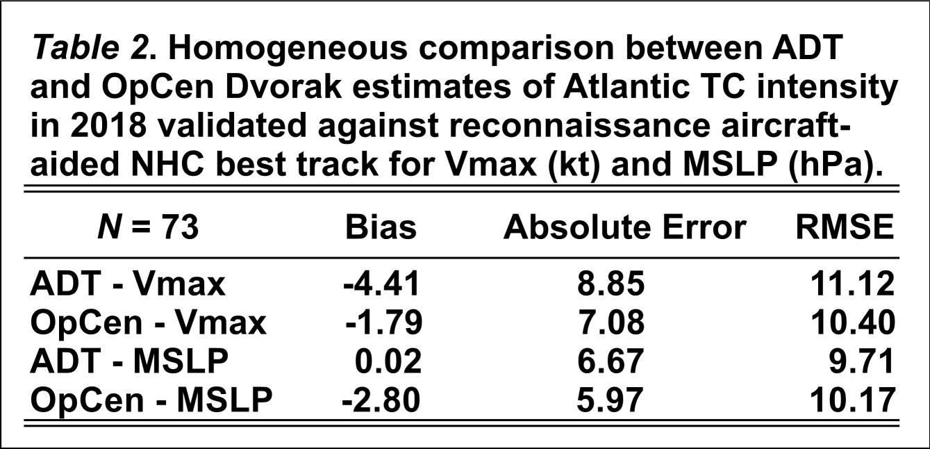
MSLP = Minimum Sea Level Pressure
OpСen = Current operating center Dvorak estimates
ADT = Version 9 of Advanced Dvorak Technique (2018)
Current Errors:
~ 7-11 kts (Vmax)
6-10 hPa (MSLP)
Hurricane Hunter Satellites
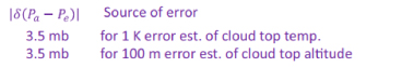
From "A Satellite-Based Stereographic Technique for Estimating the Intensity of Tropical Cyclones", by Kerry A. Emanuel, MIT Cambridge (proprietary white paper)
Excerpt from paper: "Using these values, we estimate the following error:
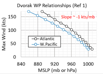
Ref 1: Ariffin, Munirah, Subramaniam Moten. Relationship Between Maximum Sustained Wind Speed and Central Pressure of Tropical Cyclones. Research Pub No. 1/2009, Malaysian Met. Dept., 2009.
△ 3.5 mb (hPa) corresponds to A 3.5 kts
Tropical Cyclone Actionable Prediction Results

HH Sat = Hurricane Hunter Satellite
*RMSE = Root Mean Square Error
RMSE for Adv. Dvorak = 9 kts
RMSE for HH Sats = 3.5 kts
The Advanced Dvorak Technique (ADT) is the current operational technique for hurricane estimates/predictions. Reduced uncertainty with our proposed constellation we will achieve:
- More than 2X better estimate of hurricane intensity (wind speed) and a corresponding improvement in damage assessment.
Historically, the average property value damaged by a Tropical Cyclone is ~$20B. For 100 kt winds, the property damage uncertainty is:
- for ADT (Dvorak) between $5B and $9.6B = $4.6B
- using our HH Sats between $9B to $11B = 2B
With more than 2X better estimate of hurricane intensity, the uncertainty in damage estimate improved by $2.6B in this case – huge for insurance and planning!
Why Is This Such A Big Deal?
Tropical Cyclones are dynamic and complex, tiny initial errors, even by a few knots in the measurement of wind speed compound with time. Reducing that uncertainty allows emergency services and local governments to prepare, plan and react both before and after landfall. Directing resources to where they need to be in the shortest possible amount of time.
Additionally, Cat Bonds (ask for supplemental slide for full detail) rely on wind
speed as a payout trigger. Our satellite system directly increases the value of Cat
Bonds while reducing the volatility by offering enhanced wind and TC measurements.
Where will it hit?
Category 4 Hurricane Approaching Landfall
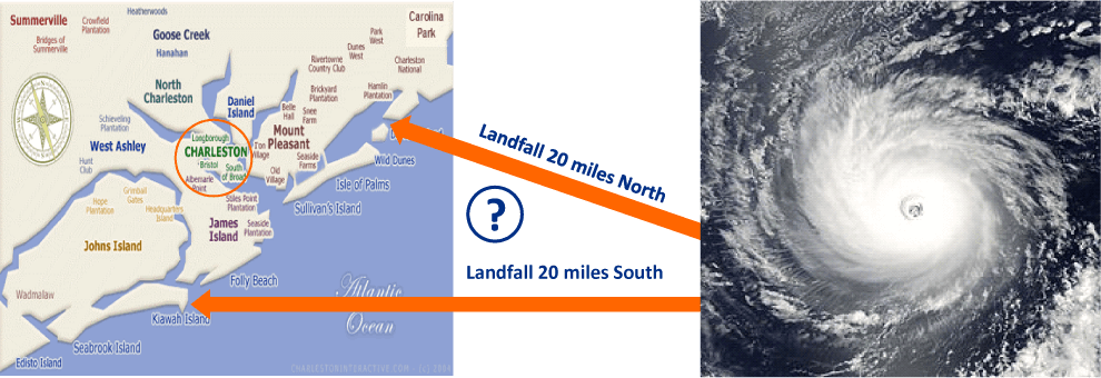
Example: Category 4 Hurricane striking Charleston S.C.
- Landfall 20 miles North → 150 mph winds from South, catastrophic storm surge
- Landfall 20 miles South → 110 mph winds from North, much weaker storm surge
Enormous
Difference in
Damage Effects
Hurricane Hunter Sats Will Provide The World’s Most Accurate Measurements, World Wide,
to Enable Forecasts of Storm Tracks and Intensities, 36 to a Few Hours Prior to Landfall!
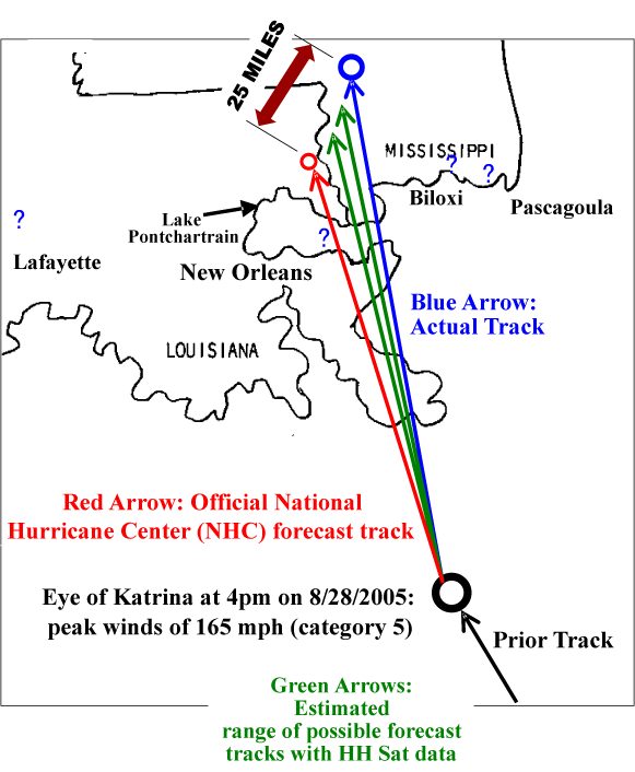
Comparison of 21-Hour PATH Forecasts made at 4 pm CDT on 8/28/2005:
|
NHC FORECAST
|
Katrina’s eye at 1pm on 8/29/05: - 45 miles North of New Orleans
|
|
ACTUAL
|
Katrina’s eye at 1pm on 8/29/05: 85 miles North-Northwest of New Orleans (NHC forecast was 40 miles Northwest of actual position
|
|
ESTIMATED Hurricane Hunter NanoSat FORECAST
|
Katrina’s eye at 1pm on 8/29/05: 65 ±10 miles North-Northwest of New Orleans, ~20 miles closer to the actual position than the NHC forecast
|
Our HH Satellite-Based Forecast PATH: 50% more accurate than NHC. Would have had about half the error in the location of Katrina’s eye than the NHC track.
Comparison of 21-Hour INTENSITY Forecasts made at 4pm CDT on 8/28/2005:
|
NHC FORECAST
|
NHC forecast at 1pm on 8/29/05: Peak winds would be 150 mph (high-end Cat 4)
|
|
ACTUAL
|
Peak winds were 100 mph (low-end Cat 3)
|
|
ESTIMATED Hurricane Hunter NanoSat FORECAST
|
Peak winds of 120±10 mph (Cat 3)
|
Our HH Satellite Based INTENSITY forecast would have been much more accurate than the NHC Forecast.
Case Study: Hurricane Katrina
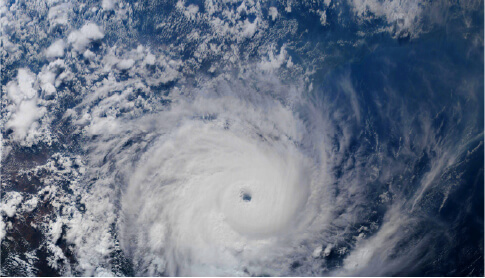
2D vs 3D a difference you can see
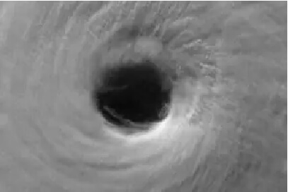
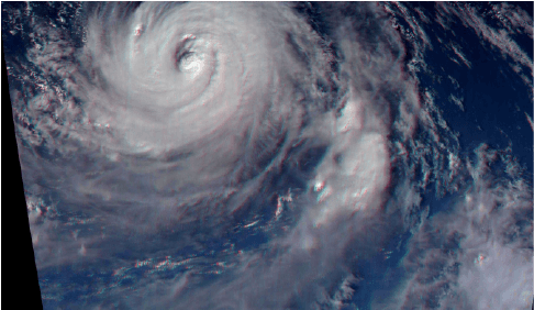
Pictured below is Typhoon Atsani as taken from the International Space Station. The far left image is unprocessed. While the middle and right image have been processed with our 3D measuring technique. Notice the eye of the typhoon far more dynamic and detailed than the standard 2D image. Don't let a pretty picture fool you, our 3D measuring technique reveals a wealth of numerical wind velocity data in the vertical axis that will allow us to delver earlier, 2X more accurate hurricane forecasts.
One of the sequence of color images acquired by the ISS crew of Typhoon Atsani on August 19, 2015. (Earth Science and Remote Sensing Unit NASA-JSC)
A red-channel close up view of the eye of Typhoon Atsani from about 01:11 GMT on August 19, 2015. This re-projected image is 225 X1 50 kilometers and approximates an overhead view. (A.J. LePage/ Tropical Weather Analytics, Inc./ NASA-JSC)
An anaglyphic stereo image (left eye red, right eye cyan) of the eye of Typhoon Atsani created using processed versions of images acquired by the ISS crew on August 19, 2015. (A.J. LePage/TWAi/NASA-JSC)
This synoptic color view of Typhoon Soudelor covers an area of 1,500 X 1,000 kilometers. It was generated by combining 177 processed images taken by the ISS crew on August 4, 2015.
(A.J.LePage/TWAi/JSC-NASA)
A red-channel close up view of the eye of Typhoon Soudelor from about 08:00 GMT on August 4, 2015. This re-projected image is 150 X 100 kilometers and approximates an overhead view.
(A.J. LePage/TWAi/NASA-JSC)
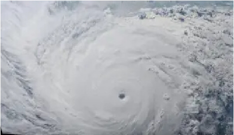
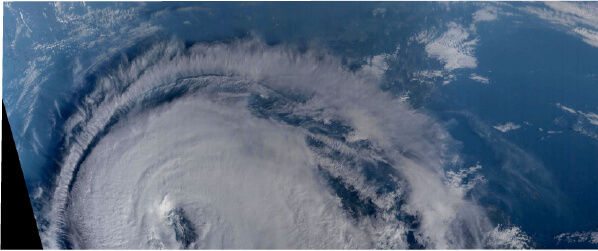
This synoptic image shows Hurricane Irma as viewed from the International Space Station (ISS) on September 5, 2017 at about 15:11 GMT. Covering an area of 2,800 x 1,200 km, this mosaic was created by remapping the original 384 color photographs taken by the crew of the ISS to approximate an overhead view before stitching them together.
(A.J. LePage/Visidyne/NASA-JSC)
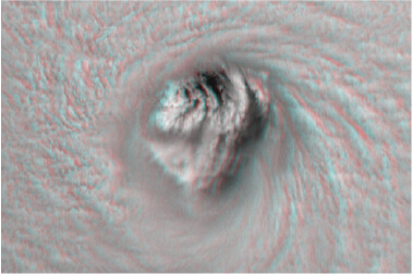
This is a close up anaglyphic 3D view (left eye red, right eye blue) of the eye of Hurricane Irma as it appeared from the ISS at about 15:11:19 GMT on September 5, 2017. It was created by combining a pair of red-filtered images taken a few seconds apart which had been processed to approximate a common overhead view covering an area of 150 x 100 kilometers.
(A.J. LePage/Visidyne/JSC-NASA)
This synoptic image shows Typhoon Soulik as viewed from the ISS on August 21, 2018 at about 20:21 GMT. Covering an area of 1,500 x 600 km, this mosaic was created by remapping the original 240 color photographs taken by the crew of the ISS to approximate an overhead view before stitching them together.
(A.J. LePage/Visidyne/NASA-JSC)
This is a close-up anaglyphic 3D view (left eye red, right eye blue) of the eye of Typhoon Soulik as it appeared from the ISS at about 22:20:48 GMT on August 21, 2018. It was created by combining a pair of color images taken five seconds apart which had been processed to approximate a common overhead view covering an area of 225 by 150 kilometers.
(A.J. LePage/Visidyne/JSC-NASA)
This synoptic image shows Hurricane Harvey as viewed from the ISS on August 25, 2017 at about 21:23 GMT (4:23 PM CDT) as the eye of the storm was approaching the Texas Gulf coast. Covering an area of 1,800 x 1,200 km, this mosaic was created by remapping the original sequence of color photographs taken by the crew of the ISS to approximate an overhead view before stitching them together.
(A.J. LePage/Visidyne/NASA-JSC)
This is a close up anaglyphic 3D view (left eye red, right eye blue) of the eye of Hurricane Harvey as it appeared from the ISS at about 21:23:08 GMT (4:23:08 CDT) on August 25, 2017. It was created by combining a pair of red-filtered images taken a few seconds apart which had been processed to approximate a common overhead view covering an area of 150 x 100 kilometers.
(A.J. LePage/Visidyne/JSC-NASA)
This is an anaglyphic 3D mosaic (left eye red, right eye blue) of Typhoon Noru as seen from the ISS at about 07:27 GMT on August 1, 2017. It was created by combining various parts the 240 images which have been processed to approximate a common overhead view covering an area of about 1,350 x 900 kilometers.
(A.J. LePage/Visidyne/JSC-NASA)