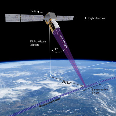
For over three years, ESA’s Aeolus satellite has used its innovative ALADIN Doppler LIDAR to provide global wind data to researchers and weather modelers. Using a pulsed UV laser pointed perpendicular to and 35° off the ground track of the satellite’s 320-kilometer orbit, ALADIN measures the light scattered by aerosols and the gases in the atmosphere to determine the line-of-sight velocity of the atmosphere (primarily the east-west component of the wind, given the polar orbit of Aeolus). These measurements are averaged over an 87-kilometer line with 24 altitude bins ranging in thickness from 250 meters in the lower atmosphere to 2 kilometers in the 20 to 30 kilometers altitude range. The typical uncertainty of these wind measurements is on the order of 2.5 meters per second in the troposphere.
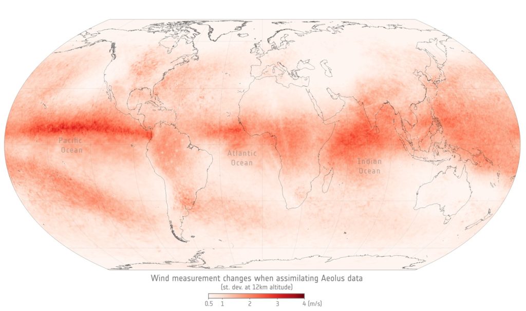
According to Mike Rennie of the European Centre for Medium Range Weather Forecasts (ECMWF), “Forecast Sensitivity Observation Impact shows that Aeolus is amongst the most important satellite missions, which is an impressive result for a demonstrator.” Gemma Halloran, of the UK Met Office, concurred saying, “Almost all weather models improved with the assimilation of Aeolus data.” Indeed, Observing System Experiments show that ESA’s Aeolus mission significantly improved short-range wind forecasts, particularly in the tropics and at mid-latitudes. The illustration below shows the standard deviation of changes when assimilating Aeolus data at an atmospheric
These significant improvements in weather forecasting come despite the shortcomings of the Aeolus/ALADIN data set. For any given 1,000-km square on the surface of the Earth, Aeolus typically provides only a single line or profile of one horizontal wind component as a function of altitude amounting to less than 300 data points once each day. Using a stereo-imaging technique which provides a contiguous view of cloud cover over a wide swath, the Hurricane Hunter Satellite constellation being developed by TWAi promises to make tropospheric wind measurements by tracking cloud motion with a spatial resolution as good as 300 to 500 meters, an altitude uncertainty of 100 meters, and a wind velocity measurement accuracy as good as 1 meter per second in all three dimensions including unique vertical wind measurements. This approach, with our five satellite-pair constellation, promises to generate hundreds of thousands of 3D wind data points up to five times per day for that same 1,000-km square patch of Earth. This multiple orders-of-magnitude increase in available 3D wind data will have a major impact on the accuracy of future forecasts.
References
“ALADIN Overview”, ESA Earth Online website, [Post]
“Aeolus paves the way for future wind lidars in space”, Post on ESA website, December 14, 2021 [Post]
“Keeper of the winds shines on”, Post on ESA website, April 26, 2022 [Post]
