Numerical weather prediction (NWP) models of hurricanes and other types of tropical cyclones are a key tool for predicting the future track and strength of these powerful storms. The May 2022 edition of the Bulletin of the American Meteorological Society (BAMS) contained an adaptation of an article entitled “High-Definition Hurricanes Improving Forecasts with Storm-Following Nests” which provides a review of these models today. It begins:
“Tropical cyclone (TC) forecasts have improved dramatically over the last few decades due to improved TC monitoring and prediction techniques, including finer resolutions in numerical weather prediction (NWP) models. Although NWP models would be ideally configured with global sub kilometer horizontal grid spacing to explicitly resolve clouds, convection, and large eddies for TC forecasts, it is simply not realistic given today’s available computational resources for operations. Currently, global NWP models used for forecasting have resolutions that are too coarse (≥ 9 km) to adequately simulate sharp gradients in the eyewall, inner core, and rainbands of TCs required for improving intensity and structure predictions.”
However, the article continues to note that methods are being developed to get around this problem.
“A nested grid (i.e., ‘nest’) is an NWP tool that allows resolution refinement over a limited area of interest (e.g., over a region of thunderstorms).” “Furthermore, storm-following nests (i.e., moving nests) are a cost-effective technology for TC forecasting in NWP models because the nests do not need to be very large. Moving nests have the capability to bridge the gap until computing resources can support uniform cloud-permitting or cloud-resolving grids in operational global models. Moving nests have been the backbone of TC intensity forecast improvements at NOAA, especially the Hurricane Weather Research and Forecasting (HWRF) model.”
The article continues with examples of the improvements that are provided by using the nested grid approach, including particularly for forecasting hurricanes.
The Hurricane Forecast Improvement Program or “HFIP” discusses the Hurricane Analysis and Forecast System of “HAFS”, which is a next-generation hurricane model which uses multi-scale multiple storm-following moving model domain nests, coupled with ocean/wave models. These developments indicate the importance of high spatial resolution in the numerical modeling/forecasting of hurricanes and strongly suggest that high spatial resolution input data would also be important.
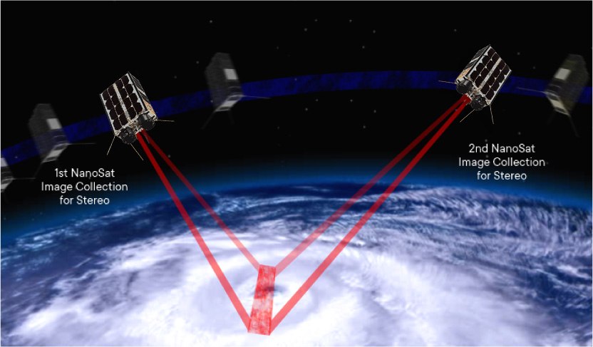
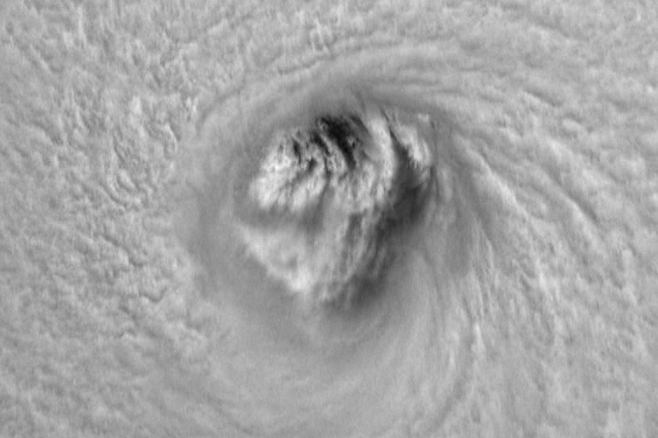
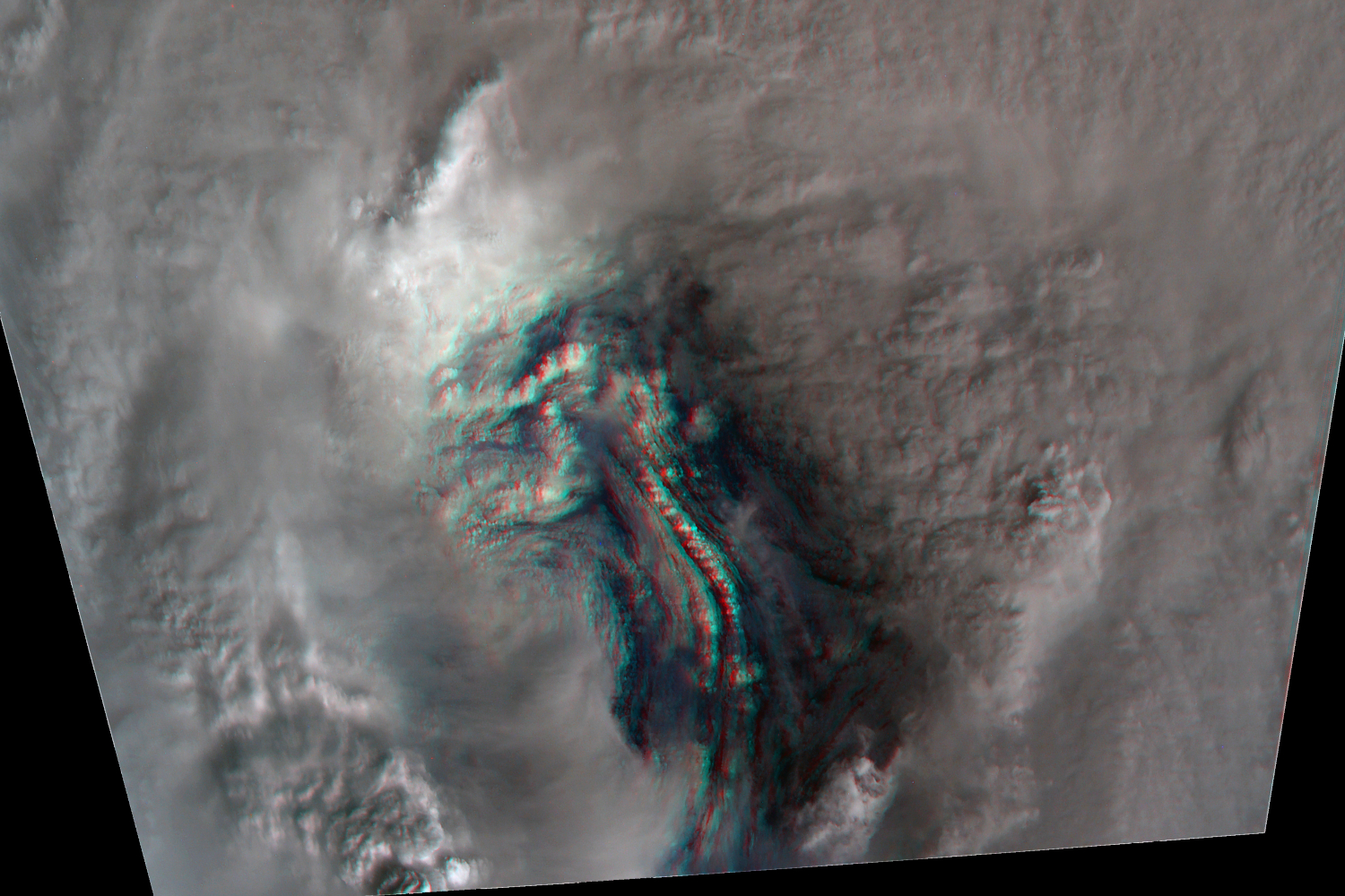
The Hurricane Hunter Satellite constellation, currently being developed by Tropical Weather Analytics, is specifically designed to address the issue of high-resolution data to support future NWP efforts (see “The Hurricane Hunter Satellites”). The Hurricane Hunter Satellite constellation, which will initially consist of five pairs of 6U CubeSats, will be capable of acquiring 100-meter class, stereographic cloud cover imagery of TCs and their surroundings – a factor of four times better resolution than NOAA’s new polar orbiting JPSS satellites. These stereographic images can also be analyzed to provide cloud altitude measurements on a spatial scale of 300 to 500 meters to a typical altitude accuracy of ±100 meters as well as 3D winds to a typical accuracy of ±1 meter per second in each component including unique measurements of the vertical wind component. Potentially, cloud altitude and 3D wind measurements for hundreds of thousands of points in a typical 2000×2000-kilometer observation by a single pair of Hurricane Hunter Satellites will provide orders of magnitude more data with better resolution than any other weather satellite system currently in orbit. With the ability to revisit almost any point on the globe every 2½ hours during daylight hours, the high resolution data returned by the Hurricane Hunter Satellite constellation is uniquely placed to help improve the next-generation hurricane model.
![]()
Related Reading
Drew LePage, “The Hurricane Hunter Satellites”, Drew Ex Machina, May 15, 2022 [Post]
John DeVore, “The Need for More Data for Hurricane Forecasting”, TWA Blog, August 5, 2022 [Post]
Drew LePage, “Using the Carnot Engine Model to Characterize Hurricanes from Orbit”, TWA Blog, July 23, 2022 [Post]
References
Ghasan J. Alakah, Jr. et al., “High-Definition Hurricanes: Improving Forecasts with Storm-Following Nests”, Bulletin of the American Meteorological Society, Vol. 103, No. 3, pp E690-E703, March 2022 [Paper]
The Hurricane Forecast Improvement Program (HFIP) [Website]
