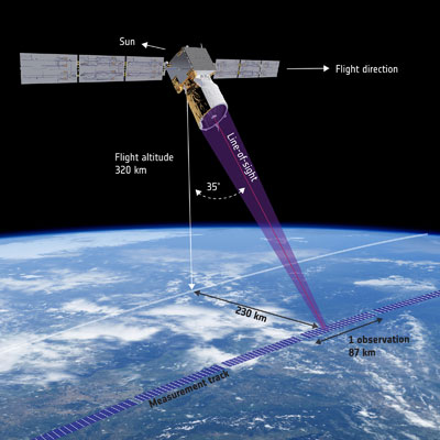
For over four years, ESA’s Aeolus satellite has used its innovative ALADIN Doppler LIDAR to provide global wind data to researchers and weather modelers. Using a pulsed UV laser pointed perpendicular to and 35° off the ground track of the satellite’s nominal 320-kilometer orbit, ALADIN measures the light scattered by aerosols and the gases in the atmosphere to determine the line-of-sight velocity of the atmosphere. These measurements are averaged over an 87-kilometer line with 24 altitude bins ranging in thickness from 250 meters in the lower atmosphere to 2 kilometers in the 20 to 30 kilometers altitude range. The typical uncertainty of these wind measurements is on the order of 2.5 meters per second in the troposphere.
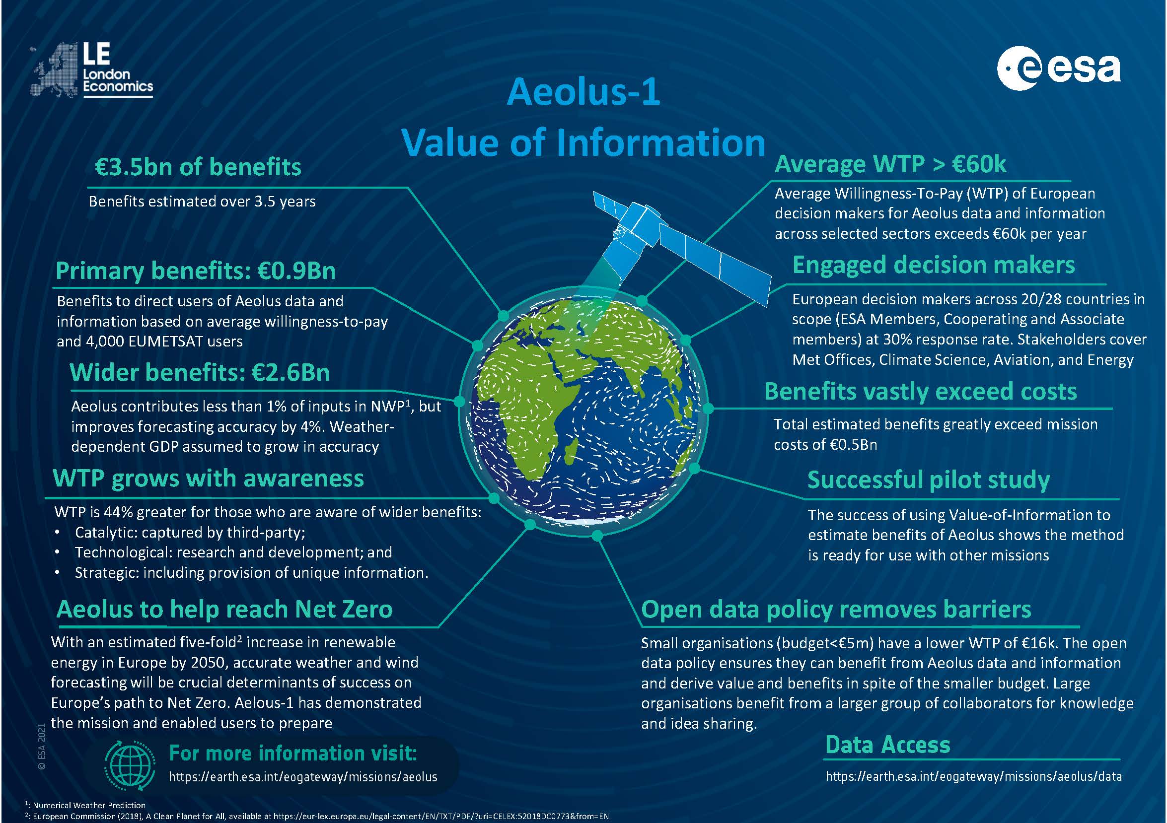
Aeolus has already exceeded its three-year design life and, with a recent switch back to ALADIN’s primary UV laser source, the satellite is expected to continue returning its unique wind profile data for several months into 2023 before either the performance of its UV laser degrades too much to return useful data or orbital decay causes the satellite to reenter the Earth’s atmosphere ending its mission. Despite the limitations of having just a single satellite returning only one component of the three-dimensional wind velocity vector (primarily the east-west component, given the 97° inclination of its near-polar orbit) along a line parallel to its ground track, Aeolus has exceeded expectations delivering high quality wind data that has routinely been used by meteorologist worldwide significantly improving weather forecasts in the process (see “How Satellite Wind Data Impacts Weather Forecasting”). A recent analysis has shown that the wind data provided by Aeolus has resulted in €3.5 billion in economic benefits for Europe during 3½ years of the mission – an excellent return on investment for a mission with an estimated cost of €481 million.
Aeolus Impact on Hurricane Forecasting
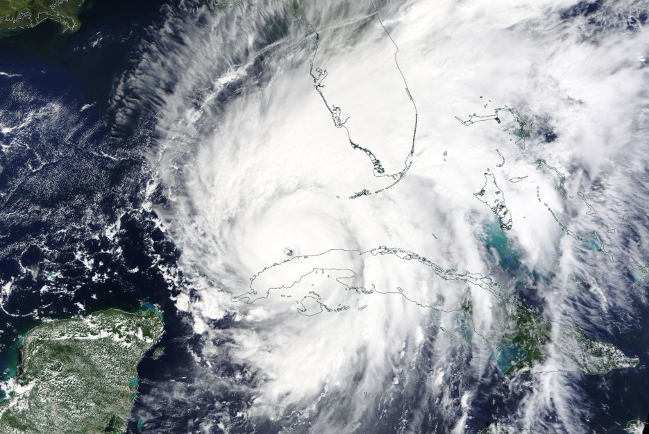
One important area where satellite wind data, like that provided by Aeolus, can have a potentially significant impact is in the forecasting of hurricanes and other types of tropical cyclones (TCs). The need for better TC forecasting was made apparent by a number of recent catastrophic storms such as Hurricane Ian which made landfall in the US on September 28, 2022 and was responsible for the deaths of 146 people as well as over $100 billion dollars in property damage just in Florida alone – figures arguably made worse by the uncertainties in the hurricane’s forecast and relating that information to local officials as well as the population in general (see “Hurricane Ian demonstrated the need to improve both the hurricane forecast and the messaging”).
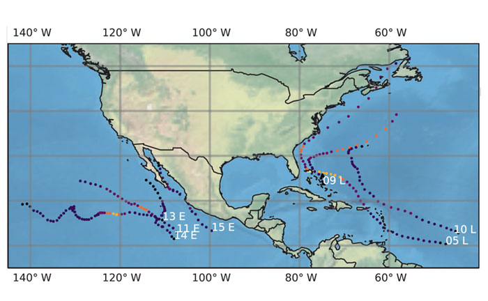
A recently published peer-reviewed paper, with Peter Marinescu (Cooperative Institute for Research in the Atmosphere, Colorado State University) as the lead author, examined how Aeolus wind profile data can affect the accuracy of hurricane forecasting using the Hurricane Weather and Research Forecasting (HWRF) model. For this study, Marinescu and his collaborators examined a total of 226 126-hour forecasts for seven different hurricanes in the East Pacific and Atlantic basins where Aeolus acquire wind profiles within about 500 kilometers of the storms’ eyes in August and September 2019. Because of the spacing of the Aeolus ground tracks, which is no better than about 2,000 kilometers at tropical latitudes, these hurricanes could not be observed during every six-hour cycle the HWRF model is run. Still, enough data were acquired over the multiple-day lifetime of these TCs to perform a meaningful analysis for when Aeolus data were available (typically every 12 hours or so, depending on the locations of the TCs and their phasing with the Aeolus ground track).
Marinescu et al. found that the inclusion of Aeolus wind profile data in the HWRF model noticeably improved intensity and size forecasts in the Eastern Pacific basin. However, the results for track forecasts and results from the Atlantic basin were mixed. The largest and most statistically significant improvements in both basins were found to occur when data from NOAA’s Hurricane Hunter Aircraft were not available, especially during the formative stages of these hurricanes well out of the normal patrol area of these weather reconnaissance assets close to the shores of the continental US (see “The Need for More Data for Hurricane Forecasting”). The most noticeable improvements in forecasting were in TC wind structure above the 400 hPa (hPa – hectopascals, the equivalent of millibars used in the US) pressure level, the equivalent to an altitude in excess of about 7 kilometers. The characterization of the winds at these higher altitudes is important in forecasting steering winds (which affect a TC’s future track) and the amount of wind shear (which affects a TC’s future intensity).
Commenting on this study, Marinescu said,
“Wind observations from platforms like Aeolus can improve the forecasting of tropical cyclones, especially in parts of the globe that do not have dedicated resources providing observations within these storms, such as those from NOAA’s Hurricane Hunter flights.
“This is the first study that looks at the impacts of Aeolus in a regional hurricane model. As we continue to better understand the Aeolus observations, additional forecast testing with even larger sample sizes can allow us to further improve how these observations are used in models.”
Future Developments in Satellite Wind Data
As work continues to assess the impact of wind profile data from Aeolus on TC forecasting, this long-lived satellite’s data will be lost sometime in 2023. While ESA has approved the development of an Aeolus-2 satellite constellation, the launch of its first element is not expected until at least 2029 resulting in a six-year gap in this important source of data. In the meantime, there are other meteorological satellite constellations currently under development which can provide an important source of satellite wind data to aid in the forecasting of TCs as well as other severe weather events.
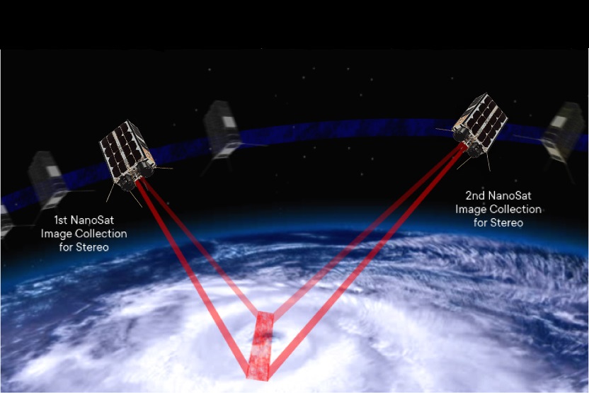
The Orbital Weather Warning System (OWWS), currently being jointly developed by the Boston-based Tropical Weather Analytics, Inc. and the Montreal-based Canada Weather Analytics, Inc., can provide high spatial resolution data on cloud altitudes and winds – vital inputs for weather models including those forecasting TCs. Initially consisting of five pairs of 6U CubeSats, the OWWS (which will include the Hurricane Hunter Satellite constellation being developed by Tropical Weather Analytics, see “The Hurricane Hunter Satellites”) with its 100-meter class, stereographic imagery will be capable of not only providing high-resolution cloud cover images, but also cloud altitude measurements to a typical accuracy of ±100 meters for tens of thousands of points over a nominal 2,000-by-2,000-kilometer observation area during each orbit. Perhaps more importantly, OWWS stereographic imagery can be analyzed to provide 3-dimensional wind data in this 2,000-by-2,000-kilometer observation area to an accuracy of ±1 meter per second in each component including unique measurements of the vertical wind component. With a spatial resolution as good as 300 to 500 meters, the OWWS wind data products will provide orders of magnitude more wind data than Aeolus or even other sources. The OWWS data will generate important inputs for mesoscale weather models including the forecasting of TCs.
The image below illustrates the vast improvement in the quantity and quality of the cloud altitude and 3D wind data to be returned by the Hurricane Hunter Satellites and other elements of OWWS. The left panel shows a simulated, 100-meter class, red-band OWWS image of the eye of Hurricane Ian. It was created using imagery returned by Landsat 8 showing Hurricane Ian at 11:57 AM EDT on September 28, 2022 as the storm was about to make landfall in the area of Fort Myers, Florida. This close up image covers an area of about 95-by-170 kilometers or just 4% of the area covered by the full, 2,000-by-2,000-kilometer size of a nominal OWWS observation session.
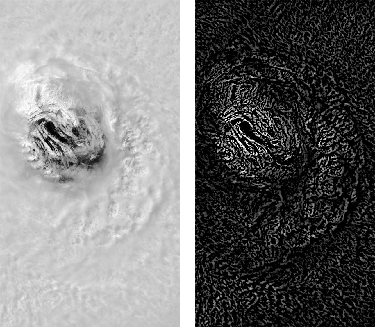
The right panel in the above illustration has been digitally filtered to highlight the outlines of the sub-kilometer-scale cloud features present in the simulated OWWS image. Stereo data processing algorithms developed by the science team at Tropical Weather Analytics will track the positions of the features observed simultaneously over time by a pair of OWWS satellites to derive their altitude and 3D motions. Even in a small scene like this with a highly structured cloud top layer, thousands of altitude and 3D wind measurements can be made including deep into the eye of the TC. This would provide much needed additional information to meteorologist to forecast wind speeds and especially rainfall intensity. For comparison, Aeolus would produce, at best, three wind profile measurements in this simulated view of only a single horizontal wind component. And given the way Aeolus collects its data and the spacing of its ground tracks, there would only be about a 1-in-20 chance that such measurements would actually be made during any random daylight overpass.
In addition to OWWS cloud altitude and 3D wind measurements meeting NOAA’s need for high resolution weather data for its hurricane modelling (see “High Definition Hurricanes – Improving Tropical Cyclone Models & Forecasts”), combining the cloud top altitude measurement near the eye of a powerful TC like this with readily available satellite cloud top temperature measurements can be used as inputs in an implementation of the Carnot Engine model for TCs to characterize the strength of these storms more accurately than other remote sensing methods currently in use or under development (see “Using the Carnot Engine Model to Characterize Hurricanes from Orbit”). With a launch date expected as early as 2024 for the first elements of the OWWS, this new, low-cost weather satellite constellation promises to provide important data on cloud altitudes and 3D winds during the Aeolus hiatus and compliment the Aeolus-2 wind profile measurements once they do become available.
General References
Peter J. Marinescu et al., “The characterization and impact of Aeolus wind profile observations in NOAA’s regional tropical cyclone model (HWRF)”, Quarterly Journal of the Royal Meteorological Society, Vol. 148, pp. 3491-3508, DOI: 10.1002/qj.4370, September 30, 2022 [Paper]
“ALADIN Overview”, ESA Earth Online website [Post]
“ESA’s wind mission could help to forecast tropical storms”, ESA Earth Online website, October 27, 2022 [Post]
“Putting a value on ESA’s Aeolus wind mission”, ESA website, November 22, 2022 [Post]
“Christmas comes early for Aeolus”, ESA website, December 15, 2022 [Post]
Related Reading
Andrew LePage, “The Hurricane Hunter Satellites”, Drew Ex Machina, May 15, 2022 [Post]
Drew LePage, “How Satellite Wind Data Impacts Weather Forecasting”, TWA Blog, May 23, 2022 [Post]
Drew LePage, “Using the Carnot Engine Model to Characterize Hurricanes from Orbit”, TWA Blog, July 23, 2022 [Post]
John DeVore, “The Need for More Data for Hurricane Forecasting”, TWA Blog, August 5, 2022 [Post]
John Devore, “High Definition Hurricanes – Improving Tropical Cyclone Models & Forecasts”, TWA Blog, August 11, 2022 [Post]

Somebody essentially lend a hand to make significantly posts I might state. That is the very first time I frequented your web page and up to now? I surprised with the research you made to create this particular put up amazing. Excellent job!